Street closure maps
Tour la Nuit, Friday May 29
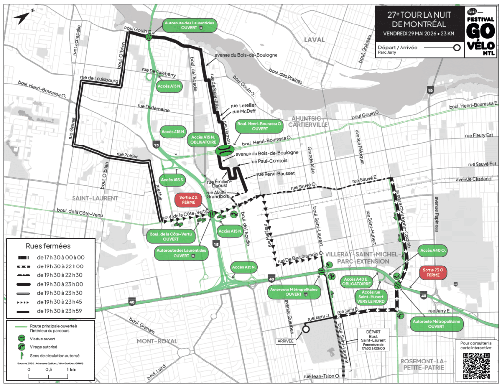
Named points OPEN (illustrated by a large green rectangle on the map) represent places where it is possible to drive in and out of the course perimeter.
Consult the interactive map of street closures
From May 29 to 31, 2026, the Go vélo Montréal Festival will be in full swing with the presentation of the Tour la Nuit and Tour de l’Île de Montréal. As these events will alter normal road traffic conditions, we invite you to plan ahead.
Here you'll find the schedule of streets closed to vehicular traffic during the Tour la Nuit and Tour de l’Île de Montréal events, as well as a map of the route and directions to the Tour sites.
If you need help planning your trip by foot, bike, public transit or car during Tour la Nuit or Tour de l’Île de Montréal, you can reach our traffic specialists by e-mail at [email protected] or at the following numbers: 514 521-8356, ext. 380 or 1 800 567-8356, ext. 380.
Infocirculation phone line schedule :
Wednesday, May 27 and Thursday, May 29, 9 a.m. to 6 p.m.
Friday, May 29, 12 a.m. to 11 p.m.
Saturday, May 30, 9 a.m. to 5 p.m.
Sunday, May 31, 7 a.m. to 4 p.m.
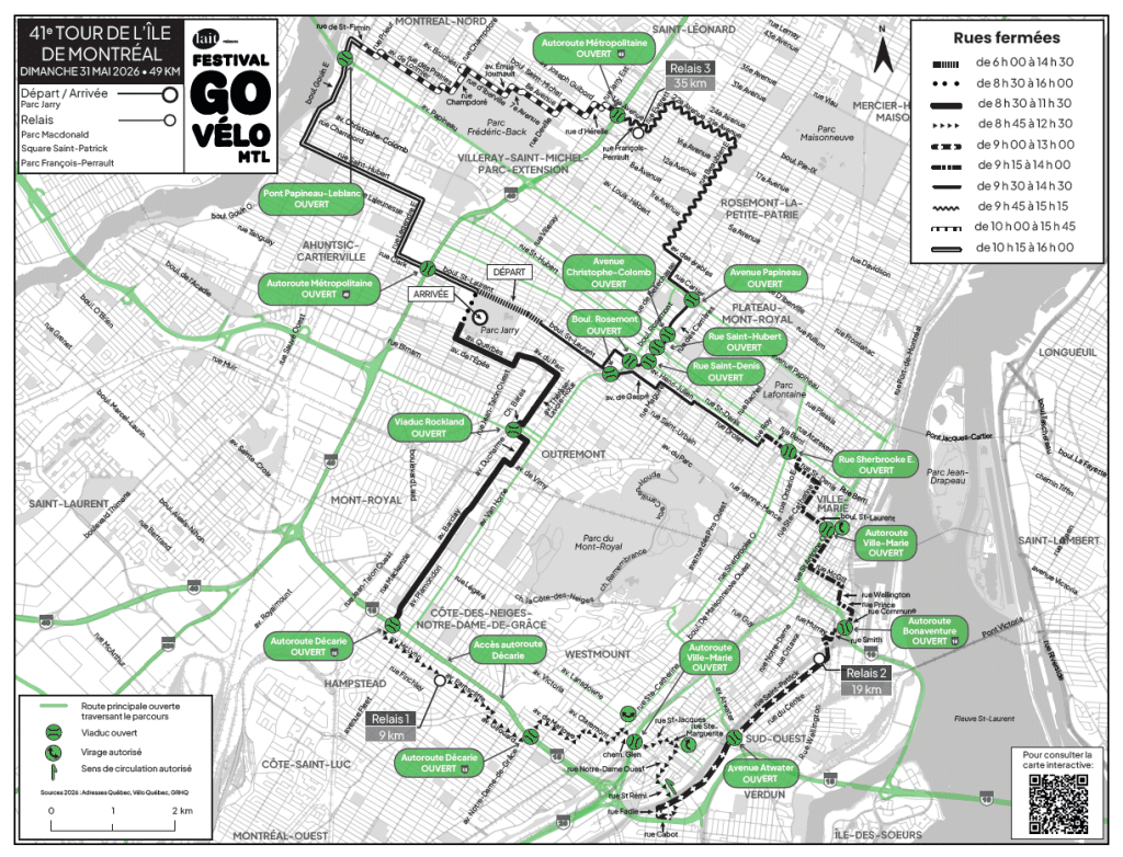
Named points OPEN (illustrated by a large green rectangle on the map) represent places where it is possible to drive in and out of the course perimeter.
Consult the interactive map of street closures
Named points OPEN (illustrated by a large green rectangle on the map) represent places where it is possible to drive in and out of the course perimeter.
Consult the interactive map of street closures
Alternative measures have been put in place to ensure access to healthcare facilities located close to the routes of a Tour la Nuit and Tour de l’Île de Montréal. We recommend :
Go to page Information for participants to plan your bike trip to Tour la Nuit.
Go to page Information for participants to plan your bike trip to take part in Tour de l’Île de Montréal.
For further information: stm.info
The Société de Transport de Montréal (STM) will allow Tour la Nuit cyclists access to the metro to get to the start of the event on the entire network. Unlike in previous years, this means that access to the metro by bike is not restricted to certain stations during the event. The first car of each train is to be avoided, but a maximum of 2 bikes/car accepted for other cars. However, tandem bikes, tricycles and trailers will not be allowed.
Prohibition on motorized personal transport devices
For safety reasons, bicycles and electric scooters are not allowed on buses or in the metro. Exceptions apply to mobility aids.
STM staff will be on hand at stations to guide you, and train frequency will be increased.
The STM would also like to inform cyclists that in the event of an emergency measure requiring the evacuation of trains, bicycles will have to remain inside the carriages, to ensure the safety of passengers.
For further information: stm.info
The Société de Transport de Montréal (STM) will give Tour de l’Île de Montréal cyclists access to the metro to get to the start of the event on the entire network. Unlike in previous years, this means that access to the metro by bike is not restricted to certain stations during the event. The first car of each train is to be avoided, but a maximum of 2 bikes/car accepted for other cars. However, tandem bikes, tricycles and trailers will not be allowed.
Prohibition on motorized personal transport devices
For safety reasons, bicycles and electric scooters are not allowed on buses or in the metro. Exceptions apply to mobility aids.
STM staff will be on hand at stations to guide you, and train frequency will be increased.
The STM would also like to inform cyclists that in the event of an emergency measure requiring the evacuation of trains, bicycles will have to remain inside the carriages, to ensure the safety of passengers.
Please consult the maps and street closing times to plan your journey and parking. It is possible to park your vehicle in some of the streets around Tour la Nuit. Please pay attention to the signs.
Please consult the maps and street closing times to plan your journey and parking. It is possible to park your vehicle in some of the streets around Tour la Nuit. Please pay attention to the signs.
Plan your drive to Tour la Nuit with Waze.
Plan your drive to Tour de l’Île de Montréal with Waze.
Vélo Québec has teamed up with Waze to bring you real-time traffic updates for Tour la Nuit and Tour de l'Île. As the Waze map is updated with data from our events, you'll be able to choose the best routes and avoid streets closed to traffic.