


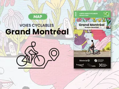
Map 2025 - Cycling routes in Greater Montreal
Published annually, the Greater Montreal bikeways map features 3450 km of bike paths in and around the Greater Montreal area, including the Oka-Mont-Saint-Hilaire cycling and walking trail and the Route verte network.
Free card.

A true reference for exploring the greater metropolitan area, this map :
- presents 3,450 km of cycling routes in Greater Montreal, including the Oka-Mont-Saint-Hilaire cycling and walking trail and the Route verte network;
- specifies types of bike lanes, bike access to bridges, river shuttles and self-service repair stations;
- The network of bike lanes and pedestrian walkways locates heritage destinations, tourist attractions and metro and commuter train stations. In short, it's all there to help cyclists get around efficiently!
Download the 2025 map here :
Metropolitan Montreal (8 Mb)
8 enlarged maps, CMM sectors (6 Mo)
Where can I get a paper card?
Available now at :
- Maison des cyclistes, 1251 Rachel Street East, Montreal.
From early May, subject to certain distribution instructions, it will be offered :
- In many bike and sports stores in the Greater Montreal area;
- At several service points in the cities of Montreal, Longueuil and Laval (Accès Montréal offices, libraries, community and leisure centers) and other cities in the Montreal Metropolitan Community.
Would you like to receive a paper card by mail?
This is possible for a processing fee of 3 $ per card.
Thanks to our partners


All rights reserved 2026
Vélo Québec
Conception de sites web : PAR Design, Agence Web