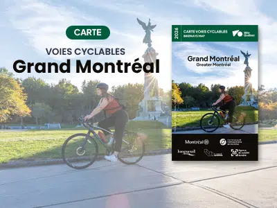
2023 Map – Greater Montréal Bikeways

Published annually, the Greater Montreal Bikeways Map presents 3450 km of bikeways in the Greater Montreal area and its surroundings, including the Oka-Mont-Saint-Hilaire Bike and Walking Trail and the Route verte network.

Free map.

A true reference for navigating the greater metropolitan area, this map :
  • presents 3450 km of cycling routes in the Greater Montreal area, including the Oka-Mont-Saint-Hilaire cycling and pedestrian pathway and the Route verte network;
  • specifies types of bike lanes, bike access to bridges, river shuttles and self-service repair stations;
  • locates heritage destinations, some tourist attractions as well as metro and commuter train stations. In short, everything is there to help cyclists get around efficiently!

Download the 2023 map here :

Greater Montreal area
8 enlarged maps, MUC sectors (6 Mb)

View the map

Where to get the paper map?

Available now at :

  • la Maison des cyclistes, 1251, Rachel East St., in Montreal.

Starting in mid-April, subject to certain distribution guidelines, it will be available:

  • In many bike and sports stores in the Greater Montreal area;
  • In several service points in the cities of Montreal, Longueuil and Laval (Accès Montréal offices, libraries, community and recreation centers) and other cities in the Montreal Metropolitan Community.

Would you like a paper map mailed to you?
This is possible for a processing fee of $3 per map.

×